With nearly 50,000 miles of streams and rivers, Virginia has it all: from mountain rivulets, creeks and major white-water to moseying float rivers and wide-mouth estuaries. More than 960 miles of our rivers have been honored as Virginia Scenic Rivers—iconic examples of Virginia’s varied, distinctive, and unique fluvial heritage. The year, 2020, marked the 50th Anniversary of the Virginia Scenic Rivers Act, passed by the General Assembly in 1970—whereas a designated Scenic River “possesses superior natural and scenic beauty, fish and wildlife, historic, recreational, geologic, cultural, and other assets.”
Virginia Scenic River segments include the Russell Fork flowing through the gorge at Breaks Interstate Park; our own urban Historic Falls of the James in Richmond (from its western boundary at the tip of Williams Island downriver to Orleans Street), as well as sections in the Middle James and the Upper James River from the confluence to Buchannan; the Nottoway River, which, at 72.5 miles, has the longest designated stretch in the state; sections of the Hughes, Chickahominy, Jordan, Rappahannock, Rivanna, and many others. See an interactive map: https://www.dcr.virginia.gov/recreational-planning/srmap
 Six new segments were designated during the 2020 General Assembly. Unfortunately, there are only two segments up for approval this year. The process is entirely driven by localities which must send a letter of interest to DCR requesting a field evaluation. The river segment which must be over 5 miles long, is then evaluated by a series of criteria which measure everything form stream corridor vegetation, water quality, fishery and significant features to history and development, etc. if the segment receives a certain cumulative score and qualifies, the local governing body must pass a resolution of support before it is presented by a local Delegate or Senator to the General Assembly for approval. For more information about what the designation does and doesn’t do, see: https://www.dcr.virginia.gov/recreational-planning/document/srdoesdoesnt.pdf
The Scenic Rivers Program originated during the 1960s, when Virginians realized that their once- pristine rivers were full of industrial waste and raw sewage. Rivers literally burned, and fish and wildlife populations were severely disrupted. Citizens and lawmakers demanded legislation to protect the state’s rivers. In 1965, a federal program called the Land and Water Conservation Fund Act was established; in Virginia, it was administered by the Department of Conservation and Recreation. The act required a state outdoor plan, so the General Assembly commissioned a series of studies that resulted in the adoption of the Virginia Scenic Rivers Act in 1970.
 The first version of the Scenic Rivers Act authorized the state to acquire riverfront property “for protection of any scenic river and transfer property to a state agency.” Needless to say, landowners were reluctant to support efforts to designate any river as scenic. However, in 1974, John Heerwald became the DCR Scenic Rivers Program administrator. A paddler and fisherman, he listened to the complaints and suggestions of outdoor enthusiasts and riverfront landowners regarding the program. Heerwald restructured the program to ensure that the Scenic River designation neither gives the state any control over land use, nor gives the public any right to use privately owned land. It simply encourages protection and preservation of the river and opens it to opportunities available with certain grants and tax assessments, with the caveat that the General Assembly must approve construction of any dam that would impede the natural flow of a designated river. As a result, more rivers are clean and free-flowing. Outdoor river recreation is exploding. Eagles have returned in impressive numbers, and sturgeon are once again migrating up the James River.
Virginia Scenic River Program: https://www.dcr.virginia.gov/recreational-planning/srmain
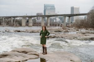
The Historic Falls of the James Scenic River—that’s Richmond’s much heralded urban whitewater—has a crazy interesting history that resulted in the General Assembly creating a special Act just for the protection of this segment in 1972. That’s way before it was incorporated into the Virginia Scenic Rivers program in 1984. More information on that can be found in Ralph Hambrick’s new book, Transforming the James River in Richmond. The Falls of the James Scenic River Advisory Committee, a state appointed committee, has met every month since 1972 and continues to do so monitoring all manner of impact along the river with monthly reports from Richmond City’s Planning and Development, Department of Public Utilities, Capital Regional Land Conservancy, Venture Richmond as well as JRA, JROC, JRAC and Friends of the James River Park. Meetings are held the third Thursday of each month and are open to the public
For more information see the 50th Anniversary video (with footage by our own Melissa Lesh): https://www.youtube.com/watch?v=Fy5o_vEjHb4&feature=youtu.be
Tricia Pearsall